Introduction
Dharche Rural Municipality is located in the Gorkha District of Gandaki Province. There are several tribal groups living in this rural municipality. The name of this rural municipality, which is dominated by Prakriti Pujan, is a combination of the words “Dhaja” and “Gang” from the local language. Gang is a hill, and Dhaja is a flag. The name of this rural municipality is Dharche, from the names Dharj and Gang, which mean the flag-burying hill. Kalo Pokhari and Ganesh Kund Trekking Trail The tribal tribes’ custom of burying flags in valley hills for work success or when leaving the village for travel protection or success, along with this practice of praising nature and people’s faith, further solidifies their status as nature’s priests.
Therefore, the tourism slogan “Open Museum of Nature and Culture—Dharche” has been prepared, and “I am for Tourists—Tourism is for Me” has been established in Dharche rural municipality. The Dharche Rural Municipality is surrounded by stunning natural beauty, tranquilly, and a diverse cultural heritage. There are many tourist destinations and a lot of potential visitors. The snow-covered mountains, lakes, rivers, streams, waterfalls, and high, foggy passes encircle the rural municipality.
There are 7 wards and 18,724 people living in this rural municipality. The six villages in the vicinity are Kerauja, Uhia, Laprak, Gumda, Kashigaon, and Lapu. The neighboring nation of China’s Tibet is to the east of Warpak Sulikot District, and Dhading is to the west аnd In the north is Chumanuvri district. The Dharche region, which is home to various castes, includes the southern village of Arughat. They also have an abundance of culture and Traditional village homes that were left standing in Dharche after the devastating earthquake of 2072 can still be seen scattered on both sides of the Budi Gandaki River.
Popular Manaslu Circuit, Manaslu Himal, Buddha Himal, Ganesh Himal, Ganesh Kund, Thaman Park, Thaman Hill, Nyauli water Falls, historical Kamala Kot, Kalo Pokhari Trail to Rubinala Low Altitude Glacier, Tato Pani, Arohi Park, Junggong Hill Cycling Trail, etc. It is the area’s top tourist destination, apart from trekking, this rural municipality offers a wide range of other activities, including climbing the Ganesh Himal and the Pabil Peak, as well as canyoning in remote waterfalls, river rafting, skiing, and rock climbing.
Introduction to the Kalo Pokhari Trekking Trail:
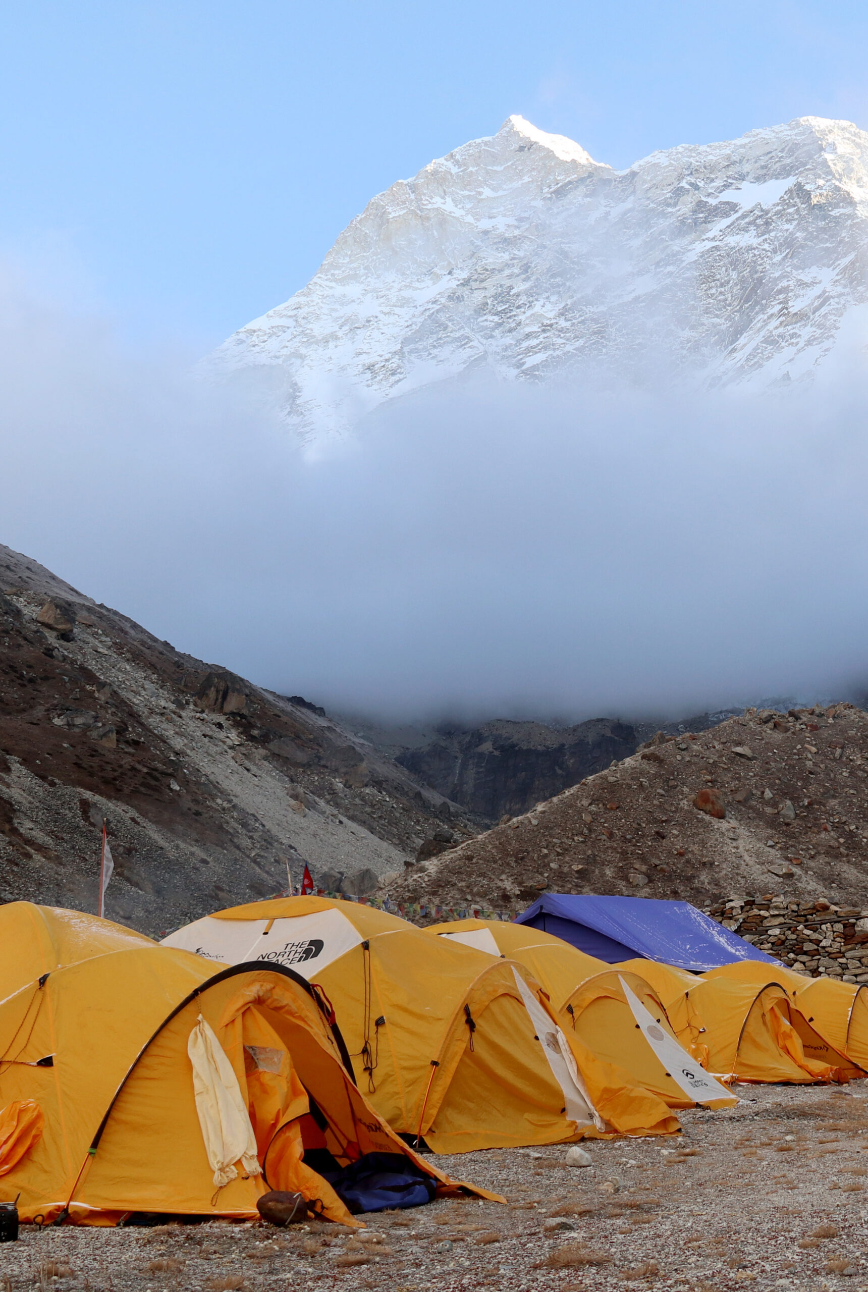
The Ganesh Kund and Kalo pokhari have a lot of cultural, religious, and natural aspects. Kalo Pokhari trekking trail, which is found in the northeast of Dharche Rural Municipality Ward No. 2 in the Gorkha District. This trail in the lap of the Ganesh Himal is equally excellent for beautiful mountain views. Mt. Manaslu, mountains above eight thousand, Harka Chuli, Himchuli, Buddha Himal, Pangpoche, Chamar, Ganesh Himal, Pavil Himal, and many other mountains can be seen. This trail is full of fauna and flora. By bus, you can travel from Kathmandu to Machakhola via Gorkha or Dhading Besi. There is a black-top road from Gorkha to Gorkha and from Dhading to Dhading Besi. After Machakhola, there is a jeep track up to Kerauja. It is possible to travel to Runchet from Kerauja by way of the following routes: Mahbung Kharka, Lambra Danda, Bungmarchet Kharka, Birim Dada, Mandrache, Sane Gang Pass (4235 m), Meghachet, Sugpa Ble, Rongja Gang, and Kalo Pokhari.
Dharche has a rich history, a vibrant religion, and a beautiful natural setting. This trail offers breathtaking mountain views, a variety of forest types, magnificently blooming rhododendron, the alluring sound of various birds chirping, and alluring waterfalls.
It is best to make a 10-12 day package for the Ganesh Kund Kalo Pokhari trekking trail. But you can make this trek as long or short as you want.
Day 1: On the first day of trekking, we started trekking by bus from Kathmandu to Arkhet. It was quite comfortable, and it takes 7 to 8 hours to reach there. Some places have unpaved motor roads. From Kathmandu to Thankot, Naubise, Dhading, Kurintar, Muglin, Abukhareni, Gorkha Bazar, and Arughat, the distance of the journey to Arkhet is 190 km. The main attraction of Gorkha District is the historic Gorkha Palace. Arkhet is a beautiful settlement, where the Ghale caste makes up the majority of the population in this area, though other castes are also present. Arkhet has a good arrangement of hotels and lodges. Arkhet offers tremendous views of Buddha Himal and Ganesh Himal.
Day 2: Kerauja to Arkhet is a straightforward journey. For the convenience of commuters and residents, a completely gravel highway has been built. This journey is both simple and fascinating because of the views of the mountains, rivers, and streams along the way. It takes 38km to travel from Arkhet to the Soti River via the villages of Manbu, Dhunchet, Yarsa, and Kasi. Turns and steep ascents and descents make this road challenging. The course of this journey After passing the Soti River on this journey, the first notable village is called Manbu. Starting in Arughat, the Manaslu Circuit Trek passes through the Soti River.
In Manbu, the Ghale caste predominates. At this location, there is an operational higher secondary school. Many students from far away came to study in Manbu. Ghale’s unique cultural and traditional Ghatu dance is performed there. This dance has distinctive qualities and is significant. This dance is performed for one day on Chaitra Dashain and three days on Chandra Purnima.
The route from Manbu to Kerauja is motorable. That motorway up there is very challenging. On this way, you will cross the villages of Katoche, Dhunchet, Dorot, Darchet, Yarsa rivers, and Yarsa village. Yarsa village is a big and beautiful village. There is a majority of Ghale and Gurung castes in this settlement. Various forests, mountains, rivers, streams, and Buddha Himal can all be seen from Yarsa. Every person in Yarsa depends on agriculture. Most sorghum, millet, buckwheat, potato, banana, and soyabean are grown here.
The beautiful Kasi village was situated in the middle of nature in a similar way. The devastating earthquake of 2072 and later Corona changed the appearance of tourists in Kasi village. Kasi village is also on the route of GHT. The village, which used to be very busy with internal and external tourists, now seems to be zero in terms of tourism. There is a majority of Ghale and Gurung people in Kasi village as well. There is a Selka kund there that is of great religious significance. It is believed that people who go to the side of the pond will make noise and do negative activities, and if they do not recite puja with a true heart, there will be bad wind and hail.
The Ghale Darwar Museum has been built in Kasi village with the help of the ward. The goods used by King Gusuk are kept in that palace. And this village also has a good arrangement of homestay for tourists.
Trekking to Ganesh Kund Kalo Pokhari can be started from Kasi village as well.
Day 3: There are 700 homes in Kerauja, which is a sizable, dense settlement with a population of about 3000. In addition to the majority of Ghale-Gurungs in this community, Kerauja has a school, ward office, helipad, health post, and view tower as well. This village has a large amount of farmland. Additionally, agriculture is a source of income for the locals. In this village, soy beans, potatoes, bananas, millet, barley, and buckwheat are also grown.
Keruja village also has a good arrangement of homestay for visitors. Trek begins in Kerauja. There is a pleasant hiking trail that ascends from this village and leads to Ganesh Kund and Kalo Pokhari. And as you continue along the same path, passing through lovely forests, numerous mountains, Semchen Lake, Milki Danda, Sadar Danda, and Bumrachet, you will eventually arrive at Mavung Kharka. Camping in the middle of a forest and enjoying the tranquilly of the night while listening to birds chirp is an entirely different experience.
Day 4: There are many up-and-down narrow trekking trails that connect Mavung Kharka and Meghachet. Some places lack even a trail or a water source along the way. Despite all of these issues, the trek’s beauty, the surrounding landscape, the dense forests, the stunning mountains, and the calming soundof chirping birds make the journey enjoyable, by way of Mavung Kharka, Sane Gang, Lambra Danda, Bidim Pakha, Bidim Danda, Mandara Danda, and Meghachet. Bidim Danda is a stunning location and vantage point for this journey. From this hill, you can see Ganesh Himal, Buddha Himal, and Manaslu Himal and many more peaks and mountains, which gives you incredible topographic views. This trek exposes us to a wide range of flora and fauna. The trail from Dhading that leads to the Ganesh KundGanesh Kund, which can only be reached after traveling further north from Meghachet, connects after passing Sane Kang.
Day 5: Meghachet is a sizable valley that lies between the districts of Dhading. The route leading to Ganesh Kund and Kalo Pokhari splits off from here. Meghachet is a large barn, and there are usually shepherds for a certain time. Additionally, Meghachet is rich in natural resources.
The trip to Runchet from here is scenic due to the presence of Kalo Pokhari. passing through Bhir Pakha, passing through Shugpachet, Tongganj, Bechet, and Rongja Kharka. Rongja Danda is a very beautiful place. The Buddha Himal, Pangpoche Himal, Chamar, Ganesh Himal, Pavil Himal, Dr. Harka Chuli, Himchuli, Ganesh Himal Range, eight thousand mountains above Mount Manaslu, and many other mountains can be seen from this hill. You can walk from Rongja Danda to the spiritual kunda Kalo Pokhari in one hour. The inhabitants of that place have had great faith in Black Pond since ancient times. According to a prominent figure in Runchet village, in the past there was a black pond below Runchet village, but due to the presence of dirt there, the black pond shifted to a place called Gumbachet, Changarchet, and from there to where it is now.
In this area, improper activities, littering, and noise are prohibited. Going down various forested hills, Pakha Kharka, Dobato (Runchet Hulchuk) Junction, Babu Kharka, Babucho, Chautara, and Kichchogang.
Runchet village is a beautiful settlement situated on the bank of Nyauli river. There are 300 households and about 2000 people. With the majority of Gurungs and ghale in this village, their religion resembles the bon, Buddhism, and Hinduism. There is a Chorten and the locals have a strong belief in it. Every year they perform a Mani puja. This puja is known locally as Mani Gumba, Yulsa Mani, or Jimbu Mani.
Day 6: The trekking trail from Runchet to Hulchuk is very scenic, with historical sagas going up and down. At some distance after leaving Roonchet, there is a trickling stream. Magar King Place can be reached after a brief climb uphill. At this location, Magar Raja and Ghale Raja frequently engaged in combat, and it is said that during the same conflict, Ghale Raja killed Magar Raja and dumped his body in the nearby water channel. Nowadays, only the ruins of the Magar king’s palace remain. The historical remnants there will vanish if the area is not protected soon. From Kamala kot, travel through the forest to Gumba Danda. This hill also leads to the Kalo Pokhari and Ganesh Kund trails. All the way, trek through fields and forests as you descend Gumba Hill to reach Hulchuk. The Dharche Rural Municipality’s Ward No. 1 includes the village of Hulchuk, which is situated on the banks of the Budi Gandaki. In this entire Ward 1, there is just one village. This village has 215 households and 1097 people. The residents of this village are also dependent on agriculture. This village mostly cultivates millet, corn, wheat, potato, and banana, as well as orange, apple, kiwi, and dragon fruit.
The people of Hulchuk have very significant traditions, art, and culture. Every year in the month of Poush, Hija Puja is performed to protect the crops in this village, and the Jhakri dance is also performed to worship the gods.
Day 7: The end of the trek from Hulchuk to Dovan trekking typically involves using that trail to reach the Manasalu trekking route. By way of Hungachet, we travel down to Dovan. Additionally, Thulo Dhunga and Shyauli Bhatti are on the route to Dovan. And to reach Machha khola from Dovan, there are numerous jeeps, and it takes 7 to 8 hours to travel by bus to get to Kathmandu.